Skip to content Transforming your infrastructure into living assets

TRANSPORT INFRASTRUCTURES

Optimize transport network management

Our Atlas InSAR and Atlas+ advanced services has been specifically designed to support the challenges you are facing during all project stages – design, construction or operation – of your transport infrastructures.’

Retro-studies gives you a deeper understanding of past vulnerabilities affecting your future construction site or existing assets ensuring you make better decision with better information. By providing thousands of measurements points beyond your project’s area of influence our data allow implementation of early stage and targeted intervention for ground-based instrumentation. Monitoring frequency is continuously adapted to your needs and site dynamics to ensure safety and infrastructure integrity without any traffic interruption. Advanced Analytics and Alert System helps you to make the most out of our data and prioritize site interventions bringing your attention where the matter is.
LINEAR INFRASTRUCTURES

Detect hot spots, mitigate risks, optimize patrols

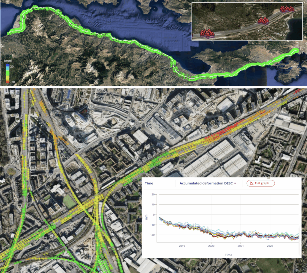
Atlas InSAR leverages the extensive coverage of radar satellite imagery to provide unmatched monitoring capabilities for large-scale linear infrastructure. Ideal for networks stretching hundreds of kilometers—such as railways, highways, and pipeline corridors—our solution enables you to:

  • Conduct a comprehensive inventory of critical areas across vast infrastructure networks.
  • Quickly identify ground movements, including subsidence, heave, active slopes, and landslide-prone zones.
  • Detect hotspots to proactively address potential threats, streamline maintenance operations, and extend the lifespan of essential transport routes

Our Atlas+ advanced analyses helps you to detect any linear trend change or acceleration and mitigate risks before they became costly.

Learn More

BRIDGES

Ensure Bridge Longevity and Safety with Atlas InSAR

Atlas InSAR is a cutting-edge tool designed to support engineers ensuring the long-term durability and structural integrity of bridges and viaducts.By measuring ground and structural displacements with millimeter-level precision, it enables:

  • Early detection of structural issues, including subsidence, pier shifts, and abutment movements.
  • Quantify the structural response to seasonal cycles, hydrological variation, and temperature-driven expansion/contraction.
  • Identification of deformations on adjacent terrain, providing a comprehensive understanding of the broader structural environment.

TUNNELS

Atlas InsAR : A Tunneling standard with unmatched benefits

With a revisit frequency of every few days, a spatial resolution of up to 1m and a density of measurement points that can reach up to 40.000km2 in urban areas, Atlas InSAR is the ideal tool to optimize cost and mitigate risks in your underground projects.

  • Clearly define the perimeter affected by dewatering activities, minimizing the risk of losing reference points for ground instruments.
  • Gain the ability to vigilantly monitor any ground movements due to volume loss
  • Identify and measure impacts on nearby buildings and infrastructure to safeguard third-party assets and facilitate claims resolutions
  • Integrate Atlas InSAR with complementary technologies like precise leveling and Automatic Total Stations to reduce ground deformation monitoring costs while providing more comprehensive data.

PORTS & AIRPORTS

Safeguard Your Transport Hubs with Reliable, Data-Driven Insights

Atlas InSAR delivers a comprehensive analysis of past and present ground movements, ensuring the safety and integrity of port and airport infrastructures.

  • High-Precision Deformation Detection: monitor subtle ground movements caused by geological hazards, construction impacts, or severe weather events.
  • Proactive Risk Management: identify early warning signs of structural degradation, enabling timely maintenance interventions that reduce repair costs and avoid operational shutdowns.
  • Operational Continuity: minimize disruptions to freight and transport schedules by maintaining safe and reliable infrastructure.

EJEMPLO TEXTO + IMAGEN (A)

Detect hot spots, mitigate risks, optimize patrols

Atlas InSAR leverages the extensive coverage of radar satellite imagery to provide unmatched monitoring capabilities for large-scale linear infrastructure. Ideal for networks stretching hundreds of kilometers—such as railways, highways, and pipeline corridors—our solution enables you to:

  • Conduct a comprehensive inventory of critical areas across vast infrastructure networks.
  • Quickly identify ground movements, including subsidence, heave, active slopes, and landslide-prone zones.
  • Detect hotspots to proactively address potential threats, streamline maintenance operations, and extend the lifespan of essential transport routes
applications transport infrastructure linear infrastructure

Our Atlas+ advanced analyses helps you to detect any linear trend change or acceleration and mitigate risks before they became costly.

Learn More